The landscape of the Central Hardwoods Bird Conservation Region (CHBCR) has changed dramatically since European settlement, as a result of timber harvest, fire suppression, wetland drainage, clearing of land for agriculture, and urbanization. Conserving the bird populations within the CHBCR requires protecting, restoring, and managing the habitats that these species evolved with and depend upon. To guide restoration efforts, conservation planners need to know where different vegetation types were once found and where, based on geology, soils, slope and aspect, restoration efforts are most likely to succeed.
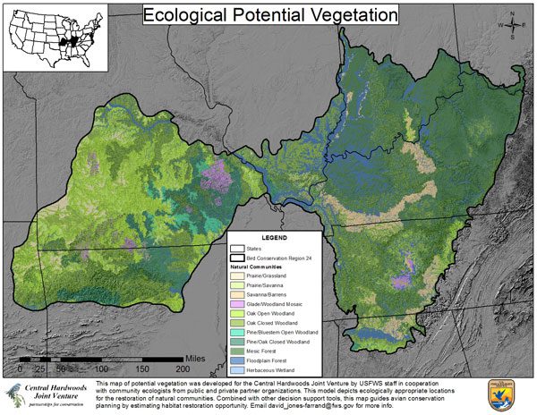
To meet this need, we created a spatial model and map of native habitat types, known as natural communities, based on the ecological potential for those habitats across the BCR.
To generate the model, boundaries for Land Type Associations within the CHBCR were delineated on a scale of 1,000 to 10,000 acres, based upon geology, soils, topography and interviews with experts. Hillside-scale landscape positions were modeled for the BCR based upon elevation, slope, aspect and solar exposure.
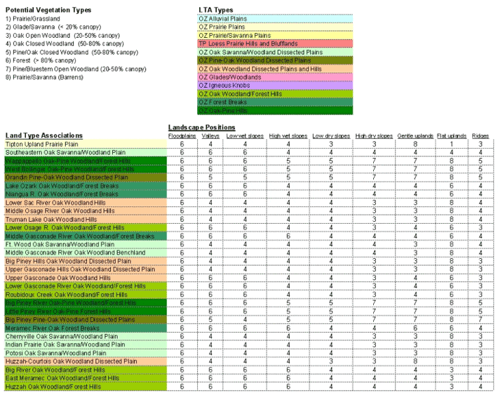
A matrix was then created using local community ecologists’ expert opinions to assign potential natural vegetation types to each landscape position within each LTA. For example, the potential vegetation type on flat uplands within the Tipton Upland Prairie Plain LTA is predicted to be prairie/grassland, while the potential vegetation type on low wet slopes in the same LTA would be oak/closed woodland. (Note that the potential vegetation types coincide with the natural community definitions below.)

The resulting map of ecological potential can be compared to current land cover to determine what changes have taken place in the vegetation type, what natural communities remain, and where restoration efforts are ecologically appropriate and likely to succeed.

By combining the model of ecological potential with known bird associations, historical species distributions and population sizes can be estimated, along with the potential of the BCR to support different bird populations. This information can help guide decisions about targeting habitat management efforts, including the type, size and scale of action.
Partners
- Tim Nigh, Missouri Department of Conservation
- Diane True, Missouri Resource Assessment Partnership
- Tom Foti, Arkansas Natural Heritage Commission
- Maria Melnechuk, The Nature Conservancy, Arkansas Field Office
- Betty Crump, Ouachita National Forest
- Mike Homoya, Indiana Department of Natural Resources, Division of Nature Preserves
- Marc Evans, Kentucky State Nature Preserves Commission
- Keith Wethington and Gary Sprandel, Kentucky Department of Fish & Wildlife Resources
- Milo Pyne, NatureServe, SE Regional Office
- Glen Smalley, Emeritus Scientist, US Forest Service, Southern Research Station
- Chris Bullington, The Nature Conservancy, Tennessee Chapter
- Roger Applegate, Tennessee Wildlife Resources Agency
- John Taft, Illinois Natural History Survey
- Steve Hupe, Shawnee National Forest

